
Luxembourg start-up WEO uses open-source satellite data and machine learning to help cities worldwide adapt to climate change, offering smart, scalable solutions for floods, fires, and heat islands.
The effects of the climate crisis are already tangible. In Luxembourg, extreme weather events like the devastating floods of July 2021 and recurring droughts between 2018 and 2022 highlight the urgency. Year after year, temperature records continue to be broken.
Adapting to this new reality is one of the key challenges of the coming decades. Solutions exist—greening urban areas to reduce heat islands, limiting soil sealing to mitigate flood intensity, managing forests to prevent fires—but these measures must be planned effectively and with sound knowledge.
That’s the mission Charlotte Wirion and Imeshi Weerasinghe set for themselves when they founded WEO, now hosted at the Luxembourg City Incubator. Their approach: delivering satellite-derived data to clients so they can enhance and accelerate their adaptation efforts.
From Theory To Action
Both originally researchers in Brussels specialising in satellite imagery for environmental applications—one in urban environments, the other in agriculture—the duo sought to move from theory to action. “We realised that applied results were difficult to achieve in academic research,” recalls Charlotte Wirion. This realisation spurred them to join Luxembourg’s Fit 4 Start accelerator in 2019. After a successful experience, they officially launched WEO in 2020.
WEO’s core idea is to harness existing technologies to support climate transition and adaptation. “There is a lot of data available—but what can we actually do with it to make a difference?” says Wirion. Satellites, she explains, provide valuable insights that are often missing when assessing the environmental impact of political decisions.
Smart Solution Using Open-Source Images
Uniquely, WEO uses open-source satellite images—primarily from NASA and the European Space Agency (ESA)—rather than costly commercial images. The economic advantage of this is the free availability of these images allows WEO to offer services globally at lower cost. Meanwhile, environmentally, the solution avoids launching new satellites, thereby reducing space debris.
The trade-off is lower resolution compared to commercial imagery. But WEO addresses this with machine learning, enhancing image resolution using other data sources. “We collect large volumes of satellite data, updated frequently,” explains Wirion. A single image isn’t enough—but combined with other datasets and deep learning models, it yields reliable, reproducible, and statistically sound indicators.
Tracking Risk Indicators
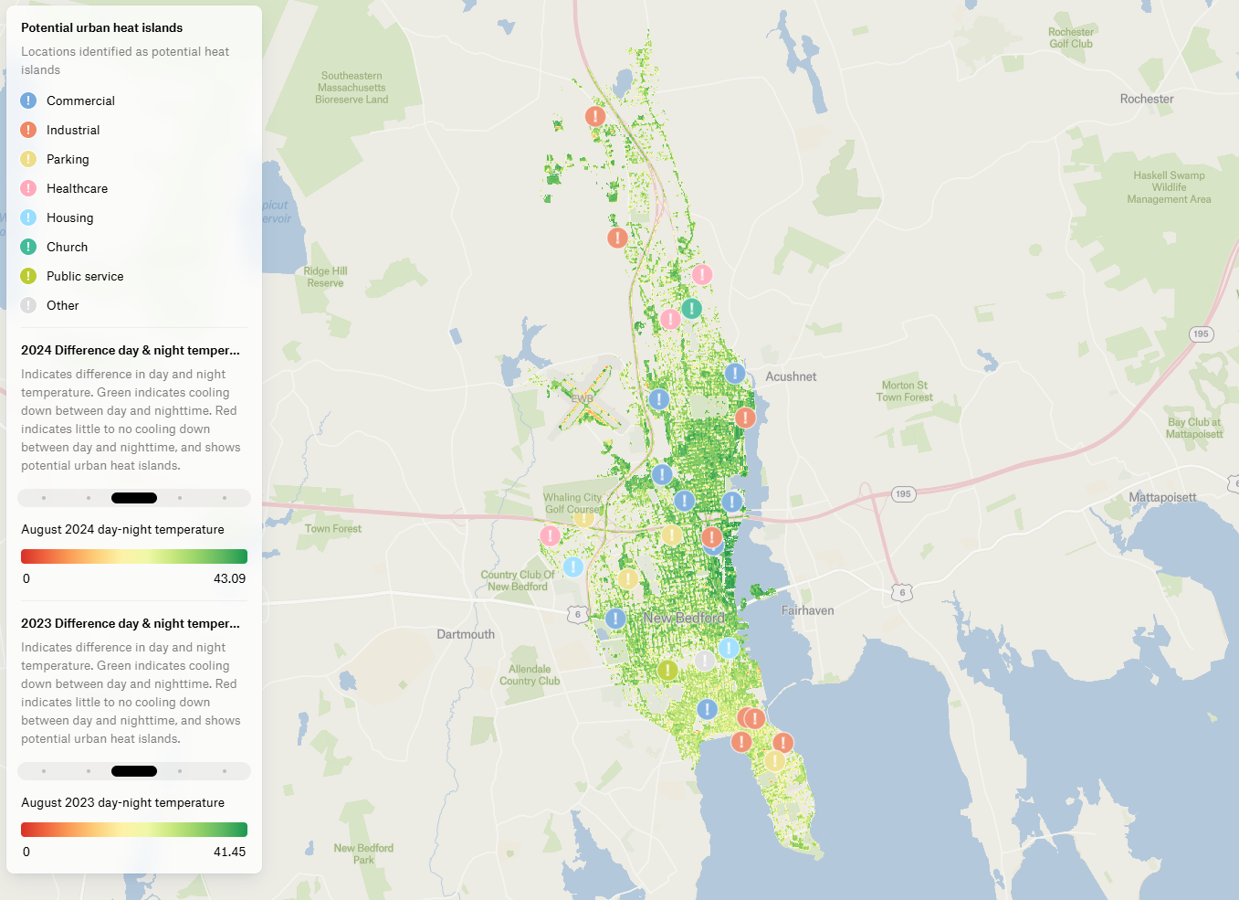
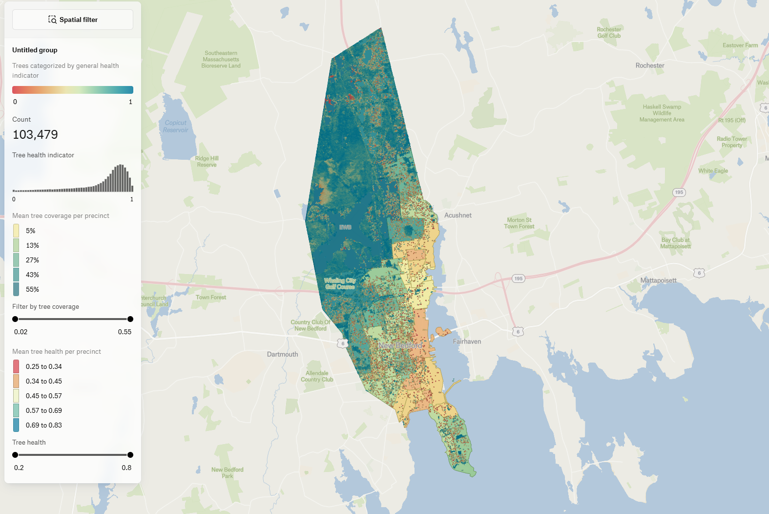
These insights are used primarily for risk prevention. For wildfires, WEO analyses tree canopy continuity to predict fire spread and assess tree health to estimate flammability. For flood risk, they map hard surfaces. To identify urban heat islands, WEO examines urbanisation, vegetation, and available space for greening. They also track surface temperatures using satellites that pass over Europe twice daily, detecting harmful differences between day and night temperatures. “Nighttime cooling is crucial for wellbeing. If that’s impaired, it indicates a heat island risk,” Wirion notes.
WEO’s clients include many Luxembourg-based public institutions—such as the Ministry of the Environment, the City of Luxembourg, and Pro-Sud, a union of municipalities. Internationally, they support entities like Brussels Environment in Belgium, a forest manager in Spain, and a solar panel operator in Portugal. WEO also works with communities in Massachusetts (USA), Lagos (Nigeria), and Dargo (Burkina Faso).
Collaboration For Innovation
While the company aims for financial sustainability, it still relies partly on research programmes with ESA and Horizon Europe. These collaborations help them strengthen their commercial position while continuing to innovate.
WEO, which now has nine part-time employees, is focused on scaling its reach. “With our now-automated products, we can operate on a larger scale,” says Wirion. But growth will remain measured: “Our philosophy is to move steadily, always ensuring there’s a real need. We’re not doing this just to build a business—we’re doing it because we believe it’s necessary. If it’s not, we stop.”
“Our philosophy is to move steadily, always ensuring there’s a real need. We’re not doing this just to build a business—we’re doing it because we believe it’s necessary”
This article was published in the 6th edition of Forbes Luxembourg.
Read more articles:
Astrobiome: Using Space To Transform Gut Health And Agriculture